About the project
The overall objective of the BONUS BASMATI project is to develop integrated and innovative solutions for maritime spatial planning from the local to the Baltic Sea Region scale. This is to be realised through multi-level governance structures and interactive information technology aiming at developing an ecologically and socio-economically sound network of protected marine areas covering the Baltic Sea.
Background for BONUS BASMATI
New ways of exploiting the sea, such as aquaculture, marine mineral resources, and marine biotechnology are rapidly growing as well as the increasing cruise tourism and extended recreational activities in coastal areas supported by the EU Strategy for growth and jobs in coastal and maritime tourism. In order to do this sustainably, the European Commission adopted a Directive on establishing a framework for maritime spatial planning in 2014. Thus, through the allocation of marine space that is based on ecosystem-based approach and integrating different interests, maritime spatial planning has become an important basis for decision-making.
The use of the seas and oceans is overall regulated by the United Nations (UN), implemented by the UN Convention on the Law of the Sea defining the rights and responsibilities. However, with the rapidly increasing exploitation of the sea and oceans, it is inevitable that conflicts may arise. Accordingly, there has been an increasing international recognition of the need to manage human activities, that influence the marine environment and its ecosystems in an integrated, cross-sectoral manner. The paradigm of Maritime Spatial Planning (MSP) is focusing on minimising the conflicts among different sea uses, which includes involving various stakeholders and sectors, while targeting sustainable growth.
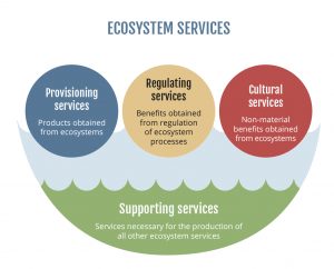
The traditional approach to spatial planning of terrestrial areas aims at balancing the use and protection of areas in support of a sustainable development, both in an environmental, societal as well as economic perspective. Similar planning systems are needed at sea and in the interconnecting areas of land and sea, the coasts, and the point of departure for the BONUS BASMATI project is the concept of ecosystem services (figure 1).

Decision support and stakeholder involvement across the Baltic Sea
MSP requires a spatially explicit framework for decision-making, therefore, the overall objectives of the project is to develop integrated and innovative solutions related to marine and coastal ecosystems services and marine protected areas. Based on the results of former MSP projects, the BONUS BASMATI project sets out to analyse governance systems and their information needs regarding MSP in the Baltic Sea region in order to develop an operational, transnational model for MSP, while maintaining compliance with existing governance systems. It also develops methods and tools for assessments of different plan-proposals, while including spatially explicit pressures and effects on maritime ecosystem services in order to create a spatial decision support system (SDSS) for the Baltic Sea region to facilitate broad access to information.
In order to achieve the goals mentioned above, a decision-support tool, the Baltic Explorer, will be developed. This system will be built on interactive information technology and support an ecosystem-based and integrated approach to MSP. The Baltic Explorer tool will be developed, taking advantage of the interdisciplinary partnership in the project team, combining competences from natural, social and technical sciences. The Baltic Explorer will be a multi-channel platform offering an interactive web-map and large multi-touch display for accessing, displaying and analysing harmonised cross-border data from marine spatial data infrastructures (MSDIs) available in the Baltic region. The Baltic Explorer will support the collaborative setting of values for different uses of marine space, as well as facilitate the negotiations between the regional stakeholders. The use of extensive stakeholder value mapping guarantees the support of ecosystem services and Blue Growth. The Baltic Explorer utilises open standards for spatial data delivery, the modern web technologies, and will be built on open source components to guarantee the free of charge use and extensibility of the application.
The BONUS BASMATI project includes seven work packages:
WP 1: Management of BONUS BASMATI
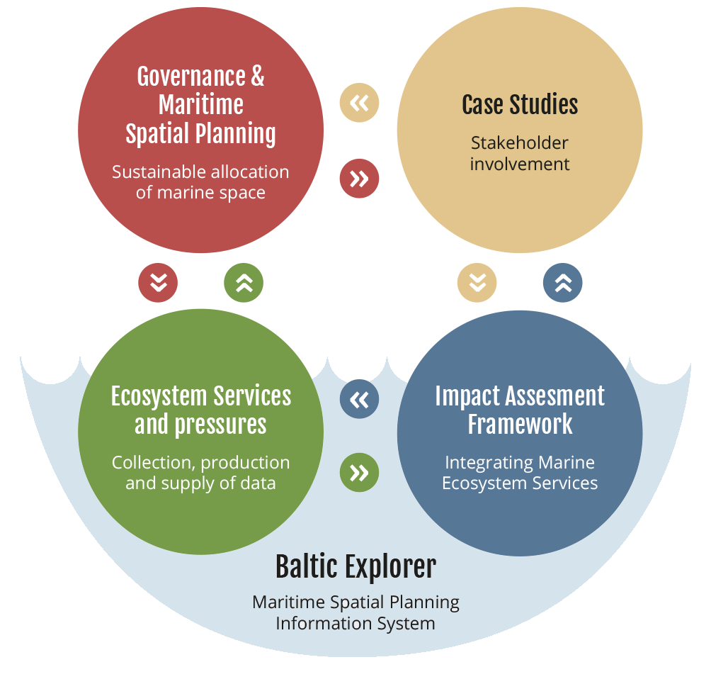
WP 2: Governance & Maritime Spatial Planning
WP 3: Data requirements and availability
WP 4: Impact assessment
WP 5: Information management & decision support
WP 6: Case studies
WP 7: Dissemination & communication
The work packages for the management (WP 1) and dissemination and communication (WP 7) activities are overarching. The rest of the work packages (WPs 2–6) include highly interconnected research activities. The overall structure of the project is illustrated in figure 2.

Enabling MSP – in the local as well as pan-Baltic scale
The interdisciplinary team of the BONUS BASMATI project includes seven partners located across the Baltic Sea Region and collaboration with other ongoing MSP projects in the region will contribute to facilitate cross-border collaboration, which is a central aim of the project. During the implementation of the project until 2020, new data will be produced and tested in assessments corresponding to policy goals to support the combined analysis of the four elements of the concept of ecosystem services: provisioning, regulating, cultural and supporting services. The impact of the project will be facilitated and assessed in transnational case studies, where integrated solutions are required. At the local scale, this will include case study areas in the Fehmarn Belt and the Gulf of Riga, and across the region a pan-Baltic case study will be performed.
